 |
 |
NOTE:
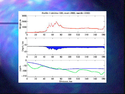
We generated four 2D topographic profiles across the central and eastern
ranges and used the height of the topography (red line), an average
crustal density of 2800 kg/m^3 and an average mantle density of 3000
kg/m^3 to construct an Airy compensation model for each profile (blue
polygon). We also used an average crustal thickness of 25 km. Note the
difference in scale of the topography (height, m) and the crustal roots
(depth, km).In calculating the predicted gravity from the Airy compensation models
with the Talwani method (blue line) and comparing to observed gravity
(green line), we found that the high topography in profiles 1 through 3 in
general matched well with the observed gravity with the exception of some
mismatched areas of basins in the LA and Mojave desert regions.