| |
Directions to Wallace Creek (area map below):
Wallace Creek, located on the North end of the Carrizo Plain National Monument, is most easily accessed via California State Hwy. 58. The Carrizo Plain is located east of San Luis Obispo and west of Bakersfield.
Directions from Interstate 5
Directions from Highway 101
.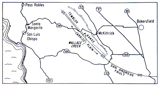
From Interstate 5 (165 miles from Los Angeles, 300 miles from San Francisco):
- Exit Interstate 5 at the Hwy. 58 exit. For Southbound visitors, turn right onto Hwy. 58. For Northbound visitors, turn right onto Tracy Ave. and then right again onto Hwy. 58.
- Follow 58 west for approximately 12.5 miles where 58 will meet Hwy. 33.
- Turn left (or south) and continue on 33, through the town of McKittrick, for approximately 1 mile.
- Watch for the sign to Santa Margarita and turn right [or west]) back onto Hwy. 58.
- Hwy. 58 winds through the Temblor Mountains and at around 14 miles, the landscape opens up and you will see the Carrizo Plain.
- Just as you exit out of the mountains, turn left onto Seven Mile Road which will take you down into the valley.
- Remain on Seven Mile Road for only a short distance (approximately 1/2 mile), where you will then turn left onto Elkhorn Road.
- Follow Elkhorn Road (a dirt road), until you reach the signs for Wallace Creek.
- Please park all vehicles in the parking lot provided. The trail provided is for foot traffic only.
|
|
|
From Highway 101 (275 miles from San Francisco, 260 miles from Los Angeles):
- Exit Hwy. 101 onto Hwy. 58 (between Atascadero and San Luis Obispo) and head east towards Santa Margarita.
- Continue east on Hwy. 58 for approximately 52 miles.
- Just before you climb into the Temblor Mountains, turn right onto Seven Mile Road which will take you down into the valley.
- Remain on Seven Mile Road for only a short distance (approximately 1/2 mile), where you will then turn left onto Elkhorn Road.
- Follow Elkhorn Road (a dirt road), until you reach the signs for Wallace Creek.
- Please park all vehicles in the parking lot provided. The trail provided is for foot traffic only.
|
|
|
|
|

 Download
a PDF Copy!
Download
a PDF Copy!
