|
|
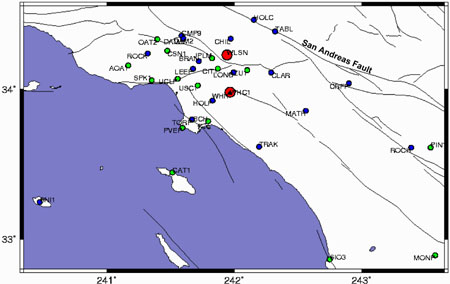
How long will it take for Los Angeles and San Francisco to meet?The crust in Southern California is constantly changing due to tectonic movement. The San Andreas fault, which is the main surface manifestation of the plate boundary between the North American and Pacific plates, is allowing most of the movement of these plates as they grind past each other. This sort of boundary is known as a transform boundary. Some day in the distant future, the movement of the Pacific plate along the San Andreas fault will eventually lead to Los Angeles and eastern San Francisco to meet and be neighbors. Just how long is that going to take, really? We can figure this out by looking at two different SCIGN stations, one on each side of the San Andreas and use their relative motion to determine how long it will take for Los Angeles and San Francisco to meet. First, let's see where the SCIGN stations are located so we can choose two appropriate stations. In order to determine what the relative motion of the North American and Pacific plates, we will need to choose stations that are on each of these plates. The San Andreas fault is labeled on the map below, which also shows the locations of the currently operating SCIGN stations. Click on the image below to see a larger version.
What you will need...1. Print-out of two SCIGN stations' time series plots on either side of the San Andreas fault (available at http://milhouse.jpl.nasa.gov/scign or on the CD) 2. These helpful equations: Rate = Distance/TimeDistance = Rate x TimeTime = Distance/Rate
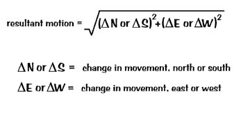
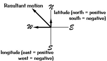
1 km = 1,000 m 1 m = 100 cm 1 cm = 10 mm 3. The following information: distance between LA and SF = approximately 500 km latitude = location north or south of the equator longitude = location east or west of the meridian Activity1. Once you have chosen the two stations that you are going to use, you need to determine the relative, or resultant, motion of the stations. In order to find this, we use the difference between the north/south movement and the east/west movement and the equation listed above to find the overall movement of the two stations. This is known as relative motion: we are trying to see how the stations, and therefore the plates that they are located upon, are moving. For example... Resultant motion = [(Station 1 - Station 2 {N/S})2 + (Station 1 - Station 2 {E/W})2]1/2 What is the rate of relative motion between the stations you chose?
2. Once you have this information, then you know the rate, or velocity of this relative motion. If you know the rate and the distance, you can figure out the amount of time it would take for Los Angeles and San Francisco to meet. You figured out the rate in part one, and the distance between LA and SF is given to you in the section above, so now you can figure out the amount of time it would take for the two cities to meet (see equations in the section above). How long will it take?
Additional questions1. What is the direction of relative motion of the two plates? (Hint: you can determine this by looking at the latitude and longitude rates on the time series plot).
2. What sort of plate boundary does the San Andreas fault represent?
3. Knowing the relative plate motion and what sort of plate boundary the San Andreas fault represents, why is it false to say that Los Angeles will fall into the ocean some day? What
is SCIGN?
|
 |
 |
 |
 |
 |
Last modified on 10/15/98 by Maggi Glasscoe (scignedu@jpl.nasa.gov)